Raiffeisen Zuger-Trophy, Etappe 04_Menzingen
Menzingen
,
Switzerland
Jun 15 - 12 Jul 2020
Raiffeisen Zuger-Trophy, Etappe 04_Menzingen - Be part of the starting field at 15 Jun 2020 in Menzingen, Switzerland. With distances ranging from 2.2 km to 8.7 km, this event offers the perfect challenge for all participants. Against the beautiful backdrop of Menzingen, an unforgettable experience awaits you - whether you want to test your limits or simply enjoy the course.
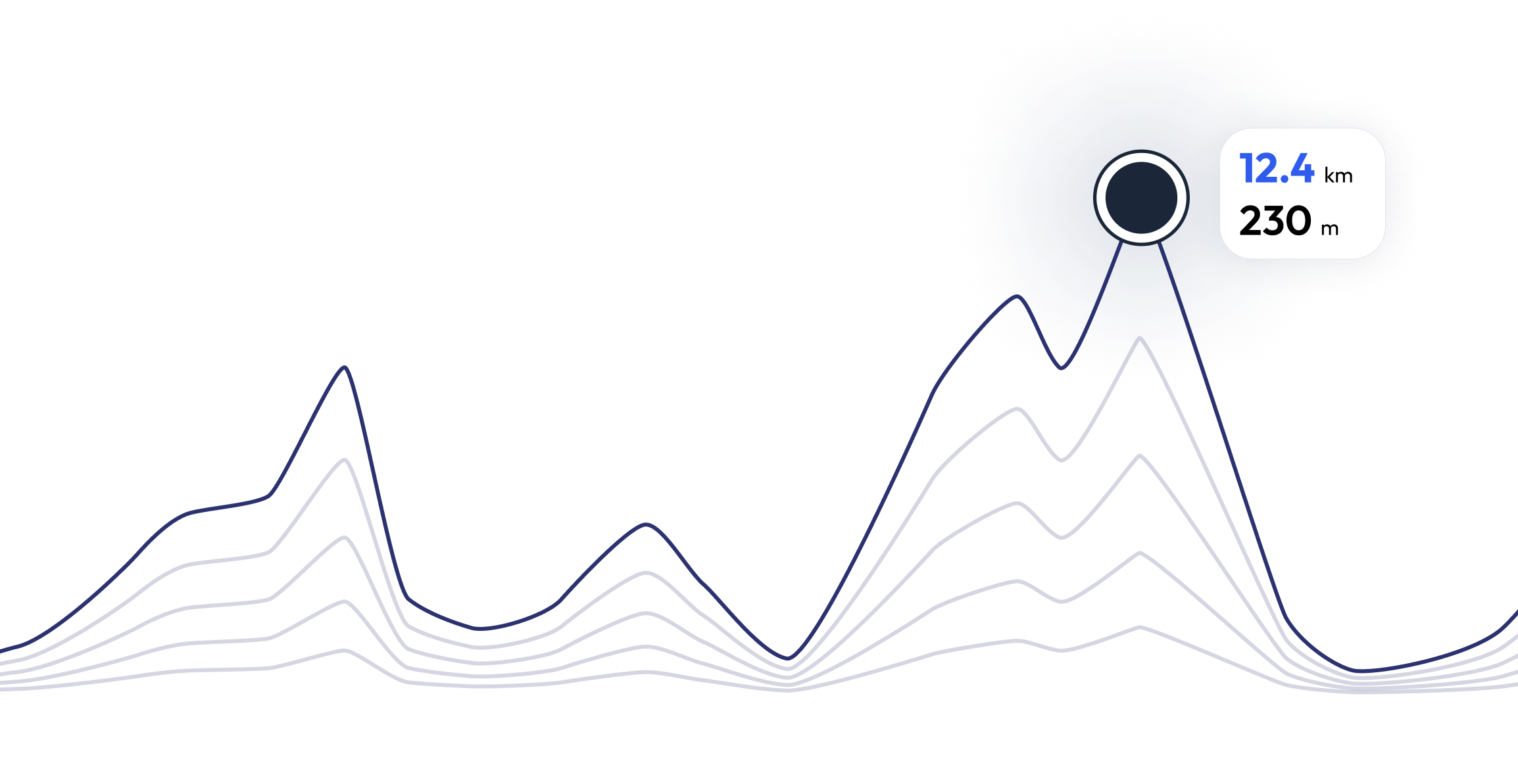
2.2mi
161ft
161ft
Register and unlock exclusive features
Registered community members can navigate each section of the elevation profile, and follow the coordinates on the map. They can also download the gpx file. Unlock these and many other exclusive features in a couple of clicks
Raiffeisen Zuger-Trophy, Etappe 04_Menzingen - Find your perfect running pace 2.2 mi
Curious what pace you need for each section of the course to reach your target time based on the elevation profile of the race? Try our pace calculator and discover different scenarios to optimize your Raiffeisen Zuger-Trophy, Etappe 04_Menzingen race tactics.
Calculated running time
00:18:00
0
km
22
m
4.33
min/km
1
km
102
m
5.12
min/km
2
km
83
m
4.47
min/km
3
km
11
m
4.23
min/km
4
km
26
m
4.32
min/km
FAQ - Raiffeisen Zuger-Trophy, Etappe 04_Menzingen 2.2 mi
Hasental, Meienrain, Schurtannen, Hasental / Wellige Strecke; Asphalt, Feldwege
Raiffeisen Zuger-Trophy, Etappe 04_Menzingen is carried out at 15 Jun 2020
Raiffeisen Zuger-Trophy, Etappe 04_Menzingen takes place in Menzingen, Switzerland
Raiffeisen Zuger-Trophy, Etappe 04_Menzingen: There are a total of 3 courses
The shortest distance available is 2.2 km, and the longest on is 8.7 km
Although there is no general rule for the minimum preparation time, we recommend at least 12 weeks of training for a race like Raiffeisen Zuger-Trophy, Etappe 04_Menzingen
If you want to prepare for Raiffeisen Zuger-Trophy, Etappe 04_Menzingen, running.COACH offers dynamic training plans tailored to the requirements. Whether you're training for distance, speed or endurance, we have customized plans to help you reach your full potential on race day.
Register now
Train for 2.2 mi of Raiffeisen Zuger-Trophy, Etappe 04_Menzingen
Raiffeisen Zuger-Trophy, Etappe 04_Menzingen - Prepare yourself optimally for your race with running.COACH! Our training plans, supported by artificial intelligence, dynamically adapt to your progress and help you achieve your target time. Whether you're aiming for a personal best or planning a successful finish, structured workouts, precise feedback and intelligent adjustments will keep you motivated and well prepared. Become part of a community that will get you to the finish line stronger than ever before!


What runners say about us?
Said López
running.COACH has helped me plan my entire season for the year. I love the flexibility with which the training plan is adjusted when an annual goal changes. I am very happy with the way it plans my week, the accuracy of the pace and heart rates, and the ease of use of the app. I find the dashboard very accurate and the stats help me keep a clear track week after week. This year my goal is to reach 800 ITRA points at three mountain ultras in Colombia, and I hope to do it with the help of running.COACH.
Karin Stoop
With the training program from running.COACH, I was able to achieve the goal of a "marathon" within a year with a varied training plan that was adapted to my performance. It is impressive how tailor-made this online training program is. My dream of finishing a marathon has come true. The different training units and the noticeable progress are very motivating.
Monika Cremosnik
Thanks to the support of my running.COACH Gold Coach, Stefanie Meyer, this year became my year of success! Intensive and always personalised training plans and always the right words and encouragement have helped me to realise my dreams. I am now a finisher in the ultramarathon in South Africa, the Comrades Marathon.
Silvia Perez
When I started training with running.COACH I found it hard to lower the intensity of each workout. But I continued because I believe that "less is more". With running.COACH I not only continue to improve my times and meet my goals but I feel strong and in very good shape. This is what allows me to finish a competition happy and keep on doing what i like the most: RUNNING!!
Angela Heller
"When I started running again after a long break, it was clear to me that I wanted to train in a structured way. With the reference 'Viktor Röthlin' my confidence grew and I bought my first subscription, a silver subscription. I was enthusiastic from the beginning and my motivation increased from training session to training session. I followed the instructions very precisely and the result for my big goal, the SwissAlpine K43, was correspondingly perfect!"
Christoph Friedli
Thanks to continued training with running.COACH, I was able to clearly improve on distances ranging from 10km to mountain running and marathon in the past couple of years, without risking an injury. Those successes encourage me to aim at new targets time and time again.
Raiffeisen Zuger-Trophy, Etappe 04_Menzingen - Be the first member of the running.COACH community to take part