The Flying Pig Marathon
Cincinnati
,
Vereinigte Staaten
02 - 04. Mai 2025

The Flying Pig Marathon of Cincinnati is a 42.195 km race held on the first Sunday in May in Cincinnati, Ohio. It was first run in 1999. and is the third largest marathon in the United States to be run for the first time.
An official Flying Pig Marathon time can be used to qualify for the Boston Marathon.
It's the biggest weekend party in town, and you can be a part of it! Whether you're a runner or a walker, whether you want to volunteer or cheer, whether you want to participate for charity or just for your own satisfaction!!!
The Flying Pig Marathoni promises to be a beautiful course that "flies" through the streets of Cincinnati, Covington and Newport. This race features a balanced and diverse course through some of the best neighborhoods in the area.
This event is a WANDA Age Group Qualifier.
3.1
mi
Flying Pig Marathon 5K
3.1mi
95ft
95ft
Registriere dich und schalte exklusive Funktionen frei
Registrierte Community-Mitglieder können durch jede Sektion des Höhenprofils navigieren und den Koordinaten auf der Karte folgen sowie die GPX-Datei herunterladen. Schalte diese und viele weitere exklusive Funktionen mit nur wenigen Klicks frei.
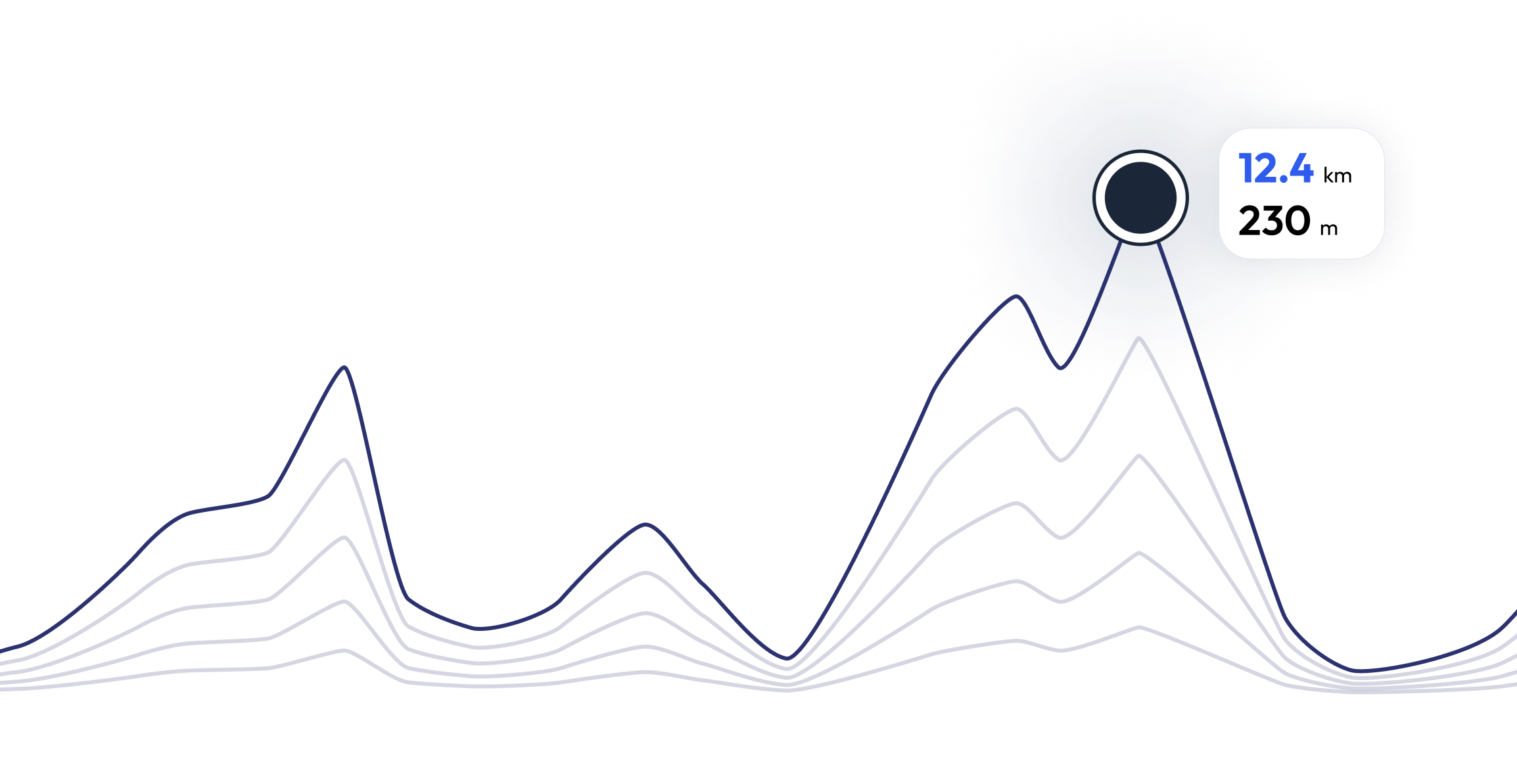
The Flying Pig Marathon - Finde dein perfektes Lauftempo 3.1 mi
Neugierig, welches Tempo du für jeden Streckenabschnitt benötigst, um basierend auf dem Höhenprofil des Rennens deine Zielzeit zu erreichen? Probiere unseren Pace-Rechner aus und entdecke verschiedene Szenarien, um deine The Flying Pig Marathon-Renntaktik gezielt zu optimieren.
Berechnete Laufzeit
00:25:00
0
km
22
m
4.33
min/km
1
km
102
m
5.12
min/km
2
km
83
m
4.47
min/km
3
km
11
m
4.23
min/km
4
km
26
m
4.32
min/km
FAQ - The Flying Pig Marathon 3.1 mi
The Flying Pig Marathon wird am 02. Mai 2025 durchgeführt
The Flying Pig Marathon findet in Cincinnati, Vereinigte Staaten statt
The Flying Pig Marathon: Es gibt insgesamt 4 Strecken
Die kürzeste Strecke misst 3.1 km, und die längste 26.2 km
Obwohl es keine allgemeingültige Regel für die minimale Vorbereitungszeit gibt, empfehlen wir mindestens 12 Wochen Training für ein Rennen wie The Flying Pig Marathon
Wenn du dich auf The Flying Pig Marathon vorbereiten möchtest, bietet running.COACH dynamische Trainingspläne, die auf die Anforderungen abgestimmt sind. Egal ob du auf Distanz, Geschwindigkeit oder Ausdauer trainierst, wir haben massgeschneiderte Pläne, die dir helfen, am Renntag dein volles Potenzial auszuschöpfen.
Jetzt registrieren
Trainieren für 3.1 mi of The Flying Pig Marathon
The Flying Pig Marathon – Bereite dich mit running.COACH optimal auf deinen Wettkampf vor! Unsere Trainingspläne, unterstützt durch künstliche Intelligenz, passen sich deinem Fortschritt dynamisch an und helfen dir, deine Zielzeit zu erreichen. Egal, ob du eine persönliche Bestzeit anstrebst oder einen erfolgreichen Zieleinlauf planst – mit strukturierten Workouts, präzisem Feedback und intelligenten Anpassungen bleibst du motiviert und bestens vorbereitet. Werde Teil einer Community, die dich stärker als je zuvor ins Ziel bringt!


Was Läufer*innen über uns sagen?
Said López
running.COACH hat mir dabei geholfen, meine gesamte Saison für das Jahr zu planen. Ich liebe die Flexibilität, mit der der Trainingsplan angepasst wird, wenn ein Jahresziel sich ändert. Ich bin sehr glücklich mit der Art und Weise, wie sie meine Woche plant, mit der Genauigkeit der die Pace und Herzfrequenzen und mit der Benutzerfreundlichkeit der App. Ich finde das Dashboard sehr genau, und die Statistiken helfen mir, Woche für Woche einen klaren Überblick zu behalten. Dieses Jahr ist mein Ziel, 800 ITRA-Punkte bei drei Berg-Ultras in Kolumbien zu erreichen, und ich hoffe, dies mit Hilfe von running.COACH zu schaffen.
Karin Stoop
Mit dem Trainingsprogramm von running.COACH konnte ich mit einem abwechslungsreichen und meiner Leistungsfähigkeit angepassten Trainingsplan das Ziel «Marathon» innerhalb eines Jahres umsetzen. Es beeindruckt, wie massgeschneidert dieses Online-Trainingsprogramm ist. Mein Traum vom Marathonfinish hat sich erfüllt. Die unterschiedlichen Trainingseinheiten und die spürbaren Fortschritte sind sehr motivierend.
Monika Cremosnik
Dank der Unterstützung meines running.COACH Gold Coach, Stefanie Meyer, wurde dieses Jahr zu meinem Erfolgsjahr! Intensive und immer persönlich der Situation angepasste Trainingspläne und die stets richtigen Worte und Zusprüche haben mir geholfen meine Träume zu verwirklichen. Ich bin nun Finisher des Ultramarathons in Südafrika dem Comrades Marathon.
Silvia Perez
Als ich anfing, mit running.COACH zu trainieren, fiel es mir schwer, die Intensität der einzelnen Trainingseinheiten zu reduzieren. Aber ich habe weitergemacht, weil ich glaube, dass "weniger mehr ist". Mit running.COACH kann ich nicht nur meine Zeiten verbessern und meine Ziele erreichen, sondern ich fühle mich auch stark und in sehr guter Form. Das ermöglicht es mir, einen Wettkampf glücklich zu beenden und weiterhin das zu tun, was ich am meisten mag: LAUFEN!!!
Angela Heller
„Als ich nach längerer Sportpause wieder mit dem Lauftraining startete, war für mich klar, dass ich strukturiert trainieren möchte. Mit der Referenz 'Viktor Röthlin' wuchs mein Vetrauen und ich löste mein erstes Abo, ein Silber-Abo. Ich war von Beginn an begeistert und meine Motivation steigerte sich von Training zu Training. Ich setzte die Vorgaben sehr genau um und bei meinem grossen Ziel dem SwissAlpine K43 war dann auch das Resultat dementsprechend perfekt!“
Christoph Friedli
„Dank kontinuierlichem Training mit running.COACH konnte ich mich in den letzten Jahren über Distanzen von 10 km über Berglauf bis zum Marathon deutlich steigern, ohne Verletzungen zu riskieren. Diese Erfolge motivieren mich, immer wieder neue Ziele anzuvisieren.“
The Flying Pig Marathon – Sei das erste Mitglied der running.COACH-Community, das teilnimmt